Your single point of reference for all your Geotechnical Inquiries
US Radar Acquisition Software
Power up and go with software geared toward the quick and easy location of a multitude of varying targets.
The core of every system is the US Radar Acquisition Software. Its clear, crisp graphical display of data in a user-friendly format makes target acquisition simple, while vibrant color palettes make those targets and features easily recognizable. Gain and averaging filters are automatically applied as required, creating data that will satisfy even the most discriminating user. Data is displayed in real time and may be recorded for further analysis or processing.
Acquisition Software is included with every system.
BASIC FEATURES
Features Include:
Auto-Calibrate: Using a unique averaging removal algorithm, the antenna and software recognize the prevailing soil conditions and calibrate the images for optimum data gathering.
Time Varying Gain: The only software/hardware integration that recognizes the duration of the pulse and applies gain accordingly. The deeper the target, the higher the gain...automatically!
User Defined Gain Algorithm: Similar to focusing a camera, the operator can increase or decrease gain on a specific depth range. Target identification and layer tracing are much easier for those hard-to-locate targets.
Backtrack Feature: Pinpoint the precise location of the target with the position indicator. When a feature is spotted in the data, simply move backward until the indicator is centered on the target.
Position Readout: Simply tap the screen on an image of interest and the distance from the beginning of your pass and the depth will be displayed (x and z coordinates). This feature works both in real time and on stored data being replayed.
measure cap4Snapshot: Store full screen images for reports, sharing with others, and printing. One tap of the touch screen “Snapshot” function and the image is saved.
Record: Full scans are stored for later analysis and review.
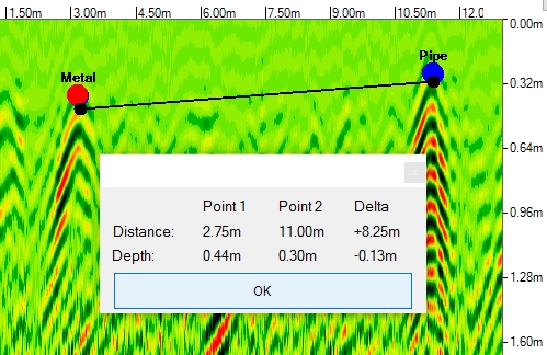
Measure Tool: User to measure the distance between two targets
Tagging/Annotation: Features can be identified and highlighted for report building purposes, then positions can be exported to a spreadsheet with either relative positions or latitudes and longitudes.
ADVANCED ACQUISITION FEATURES
This more complex software is for advanced users with applications such as geophysics that require greater filtering and data processing capabilities.
Features Include:
Advanced Depth Calibration: The depth scale can be calibrated based on targets at known depths.
Advanced Dielectric Constant Entry: The operator may enter their own values for dielectric constant.
Advanced Attenuation Entry: The operator may enter their own values for attenuation in dB/m.
Signal Loss Calculation: When entering dielectric constant and attenuation, the signal loss is calculated automatically.
Advanced Algorithms: Operator may enter advanced filtering algorithms, such as Low Pass and High Pass FIR Filters, Remove DC and Peak Envelope, for example.
USA


