Your single point of reference for all your Geotechnical Inquiries
Searching Geotechpedia for fault
Show results in
Brown I.R.
,
Wood P.J.
et al.
<p>Using a software package that can be used for either three or two-dimensional (2D) slope stability analyses of the same model we analyse the stability of columns (3D) or slices (2D) overlying a shear failure surface. The failure surface can be any shape, ...
Filed under:
Mining Engineering -
Mine Slope Stability
Reference:
APSSIM 2016, Brisbane, Australia
<p>The Northeast India region is one of the most active zones in the world; the region is jawed between the two arcs, the Himalayan arc to the north and the Indo-Burmese arc to the east. The region bounded by latitude 22-290N and longitude 90-980 E, produced ...
Filed under:
Earthquake Engineering -
Seismic Hazard Analysis
Reference:
ASSAM STATE DISASTER MANAGEMENT AUTHORITY GOVT. OF ASSAM GUWAHATI 2015
<p>The tunnel may have to be constructed across a faulted zone as it is not always possible to avoid crossing active faults. In these situations, the tunnel must tolerate the expected fault displacements and seismic action, and allow<br />only minor damages ...
Filed under:
Tunnel Engineering -
Tunnel Seismic Design
Reference:
15WCEE
Khajavi N.
,
Quigley M.
et al.
<p>High-resolution airborne LiDAR and field mapping were used to investigate a 29 km-long section of the Hurunui segment of the Hope Fault concealed beneath beech forest. Approximately 20 km of the dextral strike-slip principal slip zone (PSZ) was identified ...
Filed under:
Earthquake Engineering -
Earthquake Investigation
Reference:
Tectonophysics xxx (2014)
De Pascale G. P.
,
Quigley M. C.
et al.
<p>Analysis of light detection and ranging (lidar) derived topography combined with field data enables measurement of small (<30 m), previously unrecognized dextral offsets beneath dense temperate rainforest along New Zealand’s central Alpine fault. ...
Filed under:
Earthquake Engineering -
Earthquake Investigation
Reference:
GEOLOGY, May 2014; v. 42; no. 5; p. 411–414
Hornblow S.
,
Quigley M. C.
et al.
<p>The previously unknown Greendale Fault ruptured in the September 2010 moment magnitude (Mw) 7.1 Darfield Earthquake. Surface rupture fracture patterns and displacements along the fault were measured with high precision using real time kinematic (RTK) GPS, ...
Filed under:
Earthquake Engineering -
Earthquake Investigation
Reference:
Tectonophysics 637 (2014) 178–190
<p>The 2011 rupture of previously undetected blind faults beneath Christchurch, New Zealand, in moment magnitude (Mw) 6.2 and 6.0 earthquakes triggered major rockfalls that caused fatalities and infrastructure damage. Here we use field, geospatial, seismologic, ...
Filed under:
Rock Mechanics -
Rock Falls
Reference:
GEOLOGY, November 2014; v. 42; no. 11; p. 1–4; Data Repository item 2014345 | doi:10.1130/G36149.1 | Published online XX Month 2014 © 2014 Geological Society of America
<p>TBM tunneling is an ever-increasing prospect for underground construction, and with each new tunnel bored there are unknown elements. When boring through the earth, even extensive Geotechnical Baseline Reports can miss fault lines, water inflows, squeezing ...
Filed under:
Tunnel Engineering -
Mechanized Tunneling
Reference:
North American Tunneling Conference 2014
<p>Dynamic triggering of earthquakes by seismic waves is a robustly observed phenomenon with well-documented examples from over 30 major earthquakes. We are now in a position to use dynamic triggering as a natural experiment to probe the reaction of faults ...
Filed under:
Earthquake Engineering -
Seismology & Earthquakes
Reference:
Annu. Rev. Earth Planet. Sci. 2014.42:317-339
Luo J.
,
Monninkhoff B.
et al.
<p>The present paper focusses on different approaches of numerical model set up and discretisation based on the available geological models by using FEFLOW. In particular, the implementation of the complicated geology with regional faults and thrusts are presented ...
Filed under:
Geology -
Hydrogeology
Reference:
MODFLOW and More 2013: Translating Science into Practice - Conference Proceedings
Software by
GAEA Technologies Ltd
<p>EDMS is used to improve and standardize environmental data collection, management, and reporting in an efficient and cost-effective manner. This is accomplished by implementing a documented, auditable process for the collection, storage, and reporting of ...
Filed under:
Geoenvironmental Software -
Data Analysis and Presentation
Software by
Rockfield Software Ltd.
<p>The field scale reservoir and overburden are 3D structures with complex material and stress states that cannot be accurately described by traditional 1D methods; Elfen horizon ensures that the geomechanical aspects of the reservoir receive as much attention ...
Filed under:
Geotechnical Design Software -
General
Software by
USGS
<p>FPFIT is a Fortran program that computes double-couple fault plane solutions from P-wave first motion data using a grid search method. The companion programs FPPLOT and FPPAGE plot the results on stereo nets for interactive viewing or for printing. There ...
Filed under:
Geology Software -
Geological Data Handling
Software by
Gocad Research Group
<p>We provide 9 synthetic structural models. Their purpose is to test geomodeling algorithms, they are linked to a paper submitted in July 2014 to Computers&Geosciences.</p>
Filed under:
Geology Software -
Graphical Data Presentation
Software by
DHI
<p>Forget about having to import bathymetric river data. Begin analysing results sooner with MIKE HYDRO Basin’s data-efficient design that includes default parameter files and built-in routines for rapid delineation of rivers and sub-catchments at user-specified ...
Filed under:
Water and Groundwater Software -
Surface water management
Software by
CADS
<p>CADS RC Pile Cap Designer automatically produces a selection of suitable designs to BS 8110 and EC2 for pile caps with 2-9 piles supporting circular or rectangular columns. The software offers a range of pile cap group solutions for the input loads. After ...
Filed under:
Geotechnical Design Software -
Earth Retaining Structures
Software by
RockWare
<p>RockPack III is a package of programs useful for all phases of rock slope analysis and design where stability is controlled by the orientations and characteristics of rock mass discontinuities (joints, bedding, foliations, faults, etc). RockPack III is ...
Filed under:
Geotechnical Design Software -
Slope Stability
Software by
Seismosoft
<p>SeismoSelect is an easy and efficient way to search, select, scale and download ground motion data from different strong motion databases that are available on-line. Different criteria may be employed as the parameters of interest, with which to carry out ...
Filed under:
Earthquake Engineering Software
Software by
RocScience
<p>Slide3 is an advanced three-dimensional LEM slope stability analysis software. Slide3’s full 3D analysis features include complex geology, anisotropic materials, loading, and support.</p>
<p><strong>Block Model Import</strong>: Helps you generate ...
Filed under:
Geotechnical Design Software -
Slope Stability
Software by
Golden Software, Inc.
<p>Surfer is a full-function contouring and surface modeling package that runs under Microsoft Windows. Surfer is used extensively for terrain modeling, bathymetric modeling, landscape visualization, surface analysis, contour mapping, watershed and 3D surface ...
Filed under:
CAD - GIS Software -
Graph Tools
The Torshear machine is dedicated to the determination of the residual shear strength. The residual shear strength of soils is sometimes also termed the ultimate shear strength. This is the strength of soil when it is sheared to large displacements, for example ...
Filed under:
Laboratory Testing -
Soil Testing
<p>Direct shear testing studies the boundary conditions of natural (or artificially induced) faults or joints in fractured rocks, including cylindrical core samples and prismatic specimens. Typically, a specimen shear box holds the rock sample while a biaxial ...
Filed under:
Laboratory Testing -
Rock Testing
<div class="intro"><p>Sandvik LH514E is an electrically-driven LHD for underground loading and hauling, with a tramming capacity of 14 metric tons and a payload-to-own-weight ratio that's best in class. This durable, high capacity electric loader is proof ...
Filed under:
Ground Construction -
Earth Moving
<p>Soilmec SM-18 is a multipurpose drilling rig developed from the fusion of TREVI GROUP job-site experience and SOILMEC technological research, thus perfectly responding to the needs of professionals worldwide.<br>Its modular design is engineered for the ...
Filed under:
Ground Construction -
Surface Drilling
<p>Wire crackmeter allows to monitor the changes in the distance between two anchor points located up to 30 m apart.<br>Typical applications include measurements of large displacement associated with landslides, monitoring of rock-masses, mansonry cracks and ...
Filed under:
Monitoring -
Displacement - Movement
<p>In 2019, California was rocked by back-to-back earthquakes measuring 7.1 and 6.4, respectively. The quakes brought renewed attention to the state’s vulnerability given its boundaries around the San Andreas fault line.<br>The U.S. Geological Survey (USGS) ...
Filed under:
Advanced Knowledge
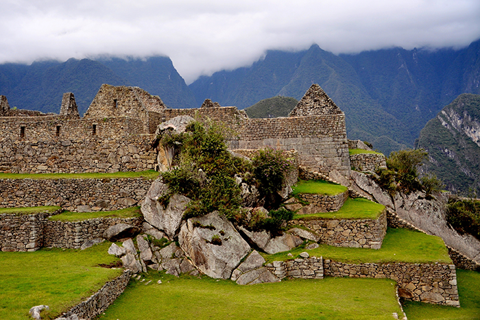
<p>As beautiful as Machu Picchu is, it's not the easiest place to get to, high up in the Andes with steep drops to the Urubamba River on three sides. Now researchers think they might know why the site was chosen.<br />The secret may lie deep below this iconic ...
Filed under:
Advanced Knowledge
<p>Scientists thought the Wilmington blind‐thrust fault that runs deep under the Los Angeles region had been dormant since the Late Pliocene era, millions of years ago. But a new study reveals that it’s very much alive, and capable of generating the ...
Filed under:
Advanced Knowledge
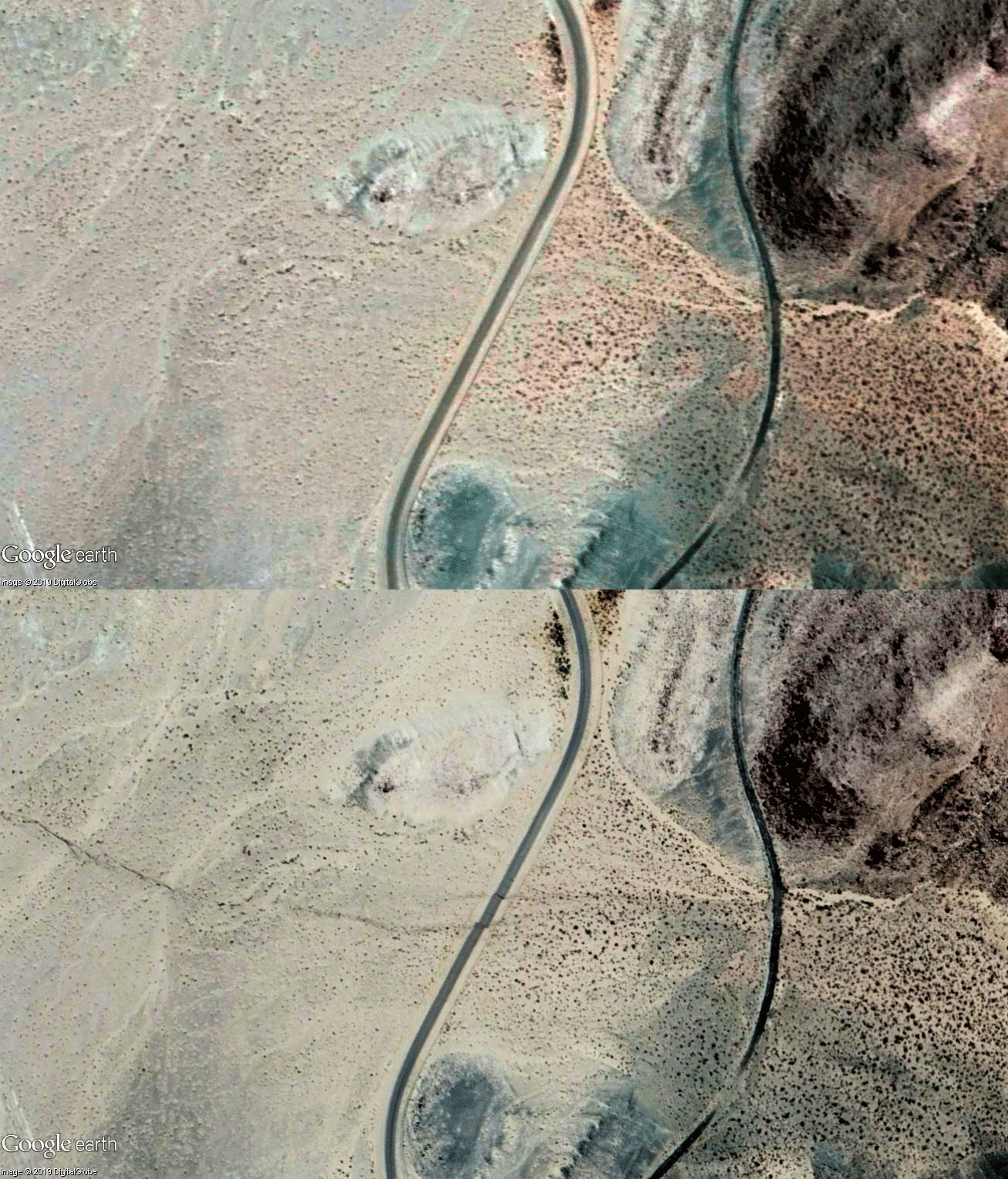
<p>Millions felt the shaking from the Ridgecrest earthquake.<br>But new satellite images offer a dramatic and instructive view of the immense power of the magnitude 7.1 quake, showing how California’s biggest earthquake in nearly two decades caused the ground ...
Filed under:
Disasters & Failures
<p>(CNN) Residents of Southern California are on high alert after a 7.1-magnitude earthquake rocked communities near the Mojave Desert on Friday, just one day after a 6.4-magnitude quake occurred in the same area.<br>The United States Geological Survey (USGS) ...
Filed under:
Advanced Knowledge
<p>The scientists have discovered that a large earthquake usually comes after a shallow mantle creep and seismic swarms, which is a process called ‘silent slip’. This process is when the Earth moves, but there is no earthquake and can lead to actual ...
Filed under:
Advanced Knowledge
<p>In December, tech billionaire Elon Musk and his tunneling startup, The Boring Company, unveiled a mile-long tunnel beneath Hawthorne—a prototype of an undergroundtransportation system called “Loop.”<br />Musk has repeatedly suggested that ...
Filed under:
Advanced Knowledge
<p>Last week, NBC New York reported that dozens of bolts fell apart during the construction of the Governor Mario M. Cuomo Bridge, a key infrastructure project of Gov. Andrew Cuomo. Some workers also alleged that there had been a cover-up about the bolts. ...
Filed under:
Construction News
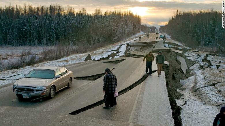
<p>The 7.0-magnitude earthquake sent residents scurrying for cover when it hit at about 8:30 a.m. Friday. The quake was centered 10 miles northeast of Anchorage.<br />The majority of the aftershocks were of a magnitude 2.5 or weaker, meaning they weren't likely ...
Filed under:
Natural Hazards
<p>SUNOL — After toiling away in the remote hills east of Interstate 680 on the Alameda-Santa Clara county line for seven years, hundreds of construction workers have finally finished the largest dam built in the Bay Area in 20 years.</p>
<p>The 220-foot ...
Filed under:
Construction News


 Search
  Clear Fields




/cdn.vox-cdn.com/uploads/chorus_image/image/62855777/LizKuball_180803_0019_HighRes.0.jpg)

