Your single point of reference for all your Geotechnical Inquiries
Maptek PerfectDig
Maptek PerfectDig is an easy-to-use system for rapidly evaluating and supporting design conformance. It allows all stakeholders to quickly compare as-builts with designs in the field and fosters real-time decision making.
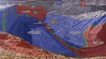
The augmented reality system cuts through the communication barriers between engineers, surveyors, supervisors and operators. Photo-realistic comparison can be made between site designs and excavation progress in real-time using 3D laser scanning technology.
PerfectDig presents enhanced photographs of the mine environment coloured with 3D design conformance information, enabling immediate, intuitive understanding. Users can choose what to view in the system simply by turning layers on and off. Results can be viewed using any web browser, without the need for specialised software.
PerfectDig is easy to use, as laser scan registration, photo correction and obstacle removal are all fully automated.
With PerfectDig, an excavation can be monitored as it progresses, a digital audit trail can be maintained, and adjustments can be identified to allow better conformance to design. This promotes efficient allocation of resources and results in improved wall stability and safety.
USA


