Your single point of reference for all your Geotechnical Inquiries
HoleBASE SI Extension for AutoCAD Civil 3D
Geotechnical Data in the BIM Process and CAD Drawings
Visualizing and sharing your data in a 3D BIM environment greatly enhances your understanding of your site and increases the quality of your engineering output.
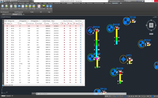
Production of drawings and models are much faster with the dynamic connection and updating of HoleBASE SI and AutoCAD Civil 3D using the HoleBASE SI Extension for AutoCAD Civil 3D.
The connection even allows you to automate the updating of your drawings and models as you get new data, allowing you to see updates to your model as they are entered into HoleBASE SI.
Site Plans and Sections
The HoleBASE SI Extension for AutoCAD Civil 3D enables you to link your HoleBASE SI project and drawing files together to facilitate fast and automated drawings. Dynamic integration with your CAD tool will change how you view and use site plans and sections in your project.
3D Visualization
Visualizing your geotechnical data in 3D environment literally offers a new dimension to your data and will enable you and your clients to understand their site easier.
CAD and BIM Integration
BIM is rapidly becoming a requirement on large construction projects around the world and this presents a challenge for CAD and Geotechnical teams. The HoleBASE SI Extension for AutoCAD Civil 3D takes on this challenge and ensures that it abides by your own CAD and geotechnical standards.
Geotechnical Module Upgrade
The Autodesk Geotechnical Module is written by Keynetix and licenced to Autodesk for supply within AutoCAD Civil 3D. It can be downloaded from your Autodesk subscription centre and is currently free of charge.
UK


