Your single point of reference for all your Geotechnical Inquiries
Planning Tool
Planning a monitoring campaign with ease
The success of a mining operation relies on its ability to deal with induced instability, a task where awareness and timely decisions are fundamental. The history of IBIS solutions showcases its effectiveness as critical monitoring system, supporting stability assessment and constantly improving productivity and safety in hundreds of operations.
Furthermore, designing an effective monitoring campaign requires a precise and quantitative definition of key parameters, such as to be able to plan where and how to install a slope monitoring radar according to the specific site needs.
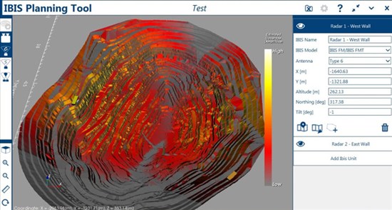
IBIS Planning Tool helps the user to easily identify what would be the best installation point to cover the area of interest. The definition of a monitoring position has never been so quick and easy. You can use any element with this valuable tool, such as
Radar
High resolution camera
Mobile instrument
Semi-permanent device
IBIS Planning Tool provides a graphical output to evaluate the coverage and the sensitivity that can be achieved with different lines of sight, with different installation settings and with different types of radars (IBIS-FM, IBIS-FMT and IBIS Rover).
Moreover, it provides valuable support to optimise multiple radar installation within an FPM360 software platform in order to cover as much as possible of the entire pit, up to 100 per cent of all the benches.
The IBIS Planning Tool can even be used to optimise the overlap between sectors monitored with different radars to achieve optimal 2D/3D information about the direction of movement, thanks to the new TrueVector functionality embedded in Guardian FPM360.
Italy


